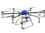
AGRIDRONE
This 10L agricultural spraying drone features a waterproof body, foldable arms, and durable frame for easy transport & long-lasting use. It supports both manual and autonomous flying modes, offering versatility and efficiency. Delivered as a ready-to-fly kit, it ensures quick setup, reliable performance, and effective crop spraying operations.
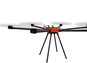
CINE-LIFTER PLUS
This heavy-load agricultural drone is engineered with a strong, durable frame and powerful design to carry and spray large capacities efficiently. It delivers stability, reliability, and high performance, making it ideal for demanding agricultural operations. Built for endurance and precision, it ensures effective spraying in challenging farming environments.
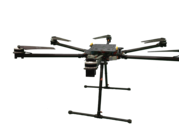
SkyGuard
This surveillance drone is built for stable, long-duration flights, equipped with advanced cameras and sensors for accurate monitoring. It provides reliable real-time data collection, making it ideal for security, inspection, and observation tasks. Durable and efficient, it ensures consistent performance in diverse environments for professional surveillance operations.
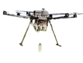
riot section drone
This riot-control drone is equipped with cameras, loudspeakers, & non-lethal payloads to support effective crowd monitoring. It provides real-time rapid deployment, & enhanced safety for law enforcement. Designed for reliability and control, it helps manage public gatherings while minimizing risks and ensuring efficient response during critical situations.


By far the best team I’ve ever worked with. They truly understood the look I was going for and completely nailed it! I would highly recommend them as a company, you simply just won’t find any better team!

It was really fun getting to know the team during the project. They were all helpful in answering my questions and made me feel completely at ease. The design ended up being twice as good as I could have ever envisioned!

Salient is by far the most astonishing WP theme out there! I literally could not be happier that I chose to buy your theme! Your regular updates and superb attention to detail blows me away every time I visit my new site!

Salient is by far the most astonishing WP theme out there! I literally could not be happier that I chose to buy your theme! Your regular updates and superb attention to detail blows me away every time I visit my new site!